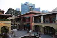
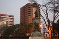
Guatemala City
| Guatemala City La Nueva Guatemala de la Asunción |
|
|---|---|
 |
|
| Nickname(s): Guate | |
| Motto: "Tú eres la ciudad" (You are the city) | |
 Guatemala City
|
|
| Coordinates: | |
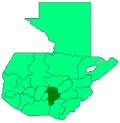
| Country | Guatemala |
| Department | Guatemala |
| Municipality | Guatemala |
| Subdivisions | Zonas (zones) |
| Established | 1773 |
| Government | |
| - Mayor | Álvaro Arzú |
| Area | |
| - City | 692 km2 (267.2 sq mi) |
| - Land | 1,905 km2 (735.5 sq mi) |
| Elevation | 1,602 m (5,256 ft) |
| Population (2010 est.)[1][2] | |
| - City | 942,348 |
| - Metro | 2,945,080 |
| Time zone | GMT-6 (UTC-6) |
| Website | Municipalidad de Guatemala |
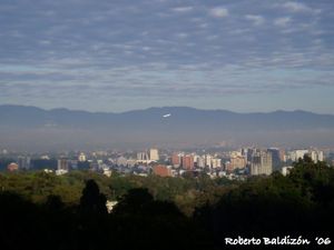
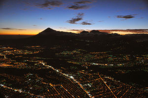
Guatemala City (in full, La Nueva Guatemala de la Asunción; locally known as Guatemala or Guate), is the capital and largest city of the Republic of Guatemala. It is also the capital city of the local Guatemala Department and the largest city in Central America.
The city is located at , in a mountain valley called Valle de la Ermita in the south central part of the country.
History
Within the confines of modern Guatemala City is the ancient Maya city of Kaminaljuyu. Kaminaljuyu dates back some 900 years and is one of America's most notable archaeological sites. The center of Kaminaljuyu was located a short distance from the oldest part of Guatemala City. However, in the late 20th century, the city grew around the ruins, and, in some cases, over some of the outlying ruins before they were protected.
Many of the several hundred temple mounds have been built over with freeways, shopping centers, commerce, luxury hotels and residential areas. The central ceremonial center of Kaminaljuyu was however protected by the Guatemalan government and is now a park within the city. There are also many ruins still in existence, protected by the government.
In Spanish colonial times, Guatemala City was a small town. It had a monastery called El Carmen, founded in 1629. The capital of the Spanish Captaincy General of Guatemala, covering most of modern Central America, was moved here after a series of earthquakes - the Santa Marta earthquakes that started on July 29, 1773 - destroyed the old capital, Antigua Guatemala.[3] On September 27, 1775, King Charles III of Spain officialized the moving of the capital. This dramatically increased the potential for expansion of the city.
Guatemala City was the scene of the declaration of independence of Central America from Spain, and became the capital of the United Provinces of Central America in 1821.
Today
Guatemala City is the economic, governmental and cultural capital of the Republic, and considered by many an economic capital of Central America.
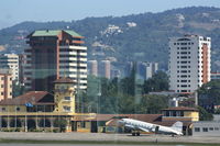
The city also functions as the main port of entry into the country, with Central America's largest international airport, La Aurora International Airport and most major highways in the country originating or leading to the city.
In addition to a wide variety of restaurants, hotels and shops, the city has a wide variety of art galleries, theaters, sports venues and museums (including some fine collections of Pre-Columbian art) and continually offers an increasing amount of cultural activities.
Guatemala City offers all the modern amenities along with important historic sites that a world class city can be expected to have ranging from an IMAX Theater to the Ícaro film festival (Festival Ícaro) featuring film produced in Guatemala and Central America.
The city continues to be a pole for the attraction of immigrants from the country's rural areas as well as foreign immigrants.
Climate
| Guatemala City | ||||||||||||||||||||||||||||||||||||||||||||||||||||||||||||
|---|---|---|---|---|---|---|---|---|---|---|---|---|---|---|---|---|---|---|---|---|---|---|---|---|---|---|---|---|---|---|---|---|---|---|---|---|---|---|---|---|---|---|---|---|---|---|---|---|---|---|---|---|---|---|---|---|---|---|---|---|
| Climate chart () | ||||||||||||||||||||||||||||||||||||||||||||||||||||||||||||
|
||||||||||||||||||||||||||||||||||||||||||||||||||||||||||||
|
||||||||||||||||||||||||||||||||||||||||||||||||||||||||||||
Despite its location in the tropics and the many micro climates found within the country, Guatemala City's elevation and the resulting moderating influence of the higher altitude enable it to enjoy a subtropical highland climate (Köppen Cwb), though depending on location, it also borders on a tropical savanna climate (Köppen Aw). Guatemala City is generally mild, almost springlike, throughout the course of the year. It occasionally gets warm during the dry season, but it is nowhere near as hot as other sea-level cities located in the tropics. The rainy season extends from May to October while the dry season covers the remainder of the year.[5] The weather in Guatemala City is also very windy; this may decrease the apparent temperature even more.
Its average annual temperature is of 19 to 22 °C (66 to 72 °F)) during the day, and 14 °C (57 °F) at night.
Average morning relative humidity: 82%, evening relative humidity: 58%. Average Dew Point is 12 °C (54 °F).[5]
| Climate data for Guatemala City | |||||||||||||
|---|---|---|---|---|---|---|---|---|---|---|---|---|---|
| Month | Jan | Feb | Mar | Apr | May | Jun | Jul | Aug | Sep | Oct | Nov | Dec | Year |
| Source: World Meteorological Organisation (UN) [4] | |||||||||||||
Structure and growth
_Map.jpg)
Guatemala City is subdivided into 22 zones designed by the urban engineering of Raúl Aguilar Batres, each one with its own streets and avenues, making it very easy to find addresses in the city. Zones are numbered 1-25 with Zones 20, 22 and 23 not yet existing.[6] Addresses are assigned according to the street or avenue number, followed by a dash and the number of meters it is away from the intersection further simplifying address location.
The city's metro area has recently grown very rapidly and has absorbed most of the neighboring municipalities of Villa Nueva, San Miguel Petapa, Mixco, San Juan Sacatepequez, San José Pinula, Santa Catarina Pinula, Fraijanes, San Pedro Ayampuc, Amatitlán, Villa Canales, Palencia and Chinautla forming what is now known as the Guatemala City Metropolitan Area.
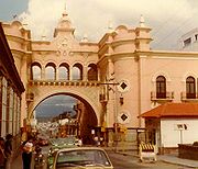
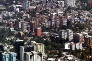
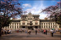
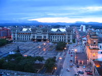
Zone One is the Historic Center, (Centro Histórico), lying in the very heart of the city, the location of many important historic buildings including the Palacio Nacional de la Cultura (National Palace of Culture), the Metropolitan Cathedral, the National Congress, the Casa Presidencial (Presidential House), the National Library and Plaza de la Constitución (Constitution Plaza, old Central Park). Efforts to revitalize this important part of the city have been undertaken by the municipal government and have been very successful thus far.
In an attempt to control rapid growth of the city, the municipal government (Municipalidad de Guatemala) headed by long time Mayor Álvaro Arzú, has implemented a plan to control its growth based on transects along its important arterial roads and exhibitting Transit-oriented development (TOD) characteristics. This plan denominated POT (Plan de Ordenamiento Territorial) aims to allow taller building structures of mixed uses to be built next to large arterial roads and gradually decline in height and density as you move away from such.[7]
Population
As of the 2002 census, the metropolitan area had a population of 2.3 million.[2] However, it has grown in excessive amounts throughout recent years. Guatemalans have a diversity of origins, with Spanish and Mestizo descent being the most common. Guatemala City also has a sizeable Indigenous population and minority groups such as Germans and other Europeans, Jewish, Asians primarily Chinese and Korean, and many groups of other Latin American origins such as Peruvian, and Colombian amongst others.
Guatemala City's population has experienced drastic growth since the 1970s with the influx of indigenous migrants from the outlying departments as well as a large influx of foreign groups. For this reason along with several others, Guatemala City has experienced some growth problems such as transportation saturation, availability of safe potable water in some areas at certain times as well as increased crime. The infrastructure, although continuing to grow and improve, at times appears to be lagging in relation to the population explosion. In other words, Guatemala City faces problems common to many other rapidly expanding cities.
Places of interest by zones
Guatemala City is subdivided into 22 zones designed by the urban engineering of Raúl Aguilar Batres, each one with its own streets and avenues, making it very easy to find addresses in the city. Zones are numbered 1-25 with Zones 20, 22 and 23 not yet existing.[8]
Zone 1
- Museos de Guatemala [1]
- Centro Histórico [2]
- National Palace of Culture
- Metropolitan Cathedral
- Mercado Central (central market)[3]
- Biblioteca Nacional (national library)
- Centro Cultural Miguel Ángel Asturias
Zone 2
- Mapa en Relieve (giant map of Guatemala, unique in the world) and surrounding parks [9]
Zone 4
- Centro Cultural Miguel Ángel Asturias
- Cuatro Grados Norte revitalized pedestrian area and cultural district
- Visa Immigration Office for all foreigners
Zone 5
- Estadio Mateo Flores
Zone 7
- Kaminaljuyu, Museo Miraflores [4], Miraflores one of the biggest malls in the city.
Zone 9
- Torre del Reformador (Tower of the Reformer).
- Parque de la Industria, fairgrounds [5]
- Avenida Reforma and El Obelisco, a parklike boulevard
Zone 10
- Museo Ixchel del Traje Indígena (Mayan dress museum) [10]
- Museo Popol Vuh
- Zona Viva entertainment district
- Botanical garden [11]
- Plaza Fontabella
Zone 13
- Museo Nacional de Arqueología y Etnología [12]
- Museo de Arte Moderno (Art Museum)
- Museo de los Niños (Children's Museum)
- Museo Nacional de Historia Natural (Natural History Museum)
- La Aurora Zoo [13]
- La Aurora International Airport
- Avenida de las Américas
- Domo Polideportivo Indoor Sports Stadium
- Mercado de Artesanías, Artscrafts and handicrafts Market
- Reloj de Flores (Landsaped Floral Clock)
- Antiguo Aqueducto (Remains of the Historical Aqueduct)
- Justo Rufino Barrios Monument (Monument of one of Guatemala's much acclaimed past President, responsible for the construction of the National Palace.)
- Tecún Úman Monument (Monument to a famed Mayan leader and warrior in Guatemala's History)
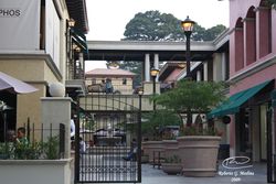
 Zone 14, Guatemala City in front of Plaza Colón |
 Tadeus building in Zone 14, Guatemala City |
 Plaza Colón, Av. de las Américas, Guatemala City |
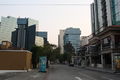 3ra Avenida, Zone 10, Guatemala City (Zona Viva) |
Transportation
- The newly renovated and expanded La Aurora International Airport lies in the southern part of the city and is the main gateway to the country.
- Urban public transportation is provided mainly by bus and recently supplemented with a BRT System. Guatemala City is the spot where the 5 main highways of the country start. (Highway to the Atlantic, to El Salvador, to the Coast, to the Altiplano and to Peten.) The construction of freeways and underpasses by the municipal government, the implementation of reversible lanes during peak rush hour traffic flows, as well as the establishment of the Department of Metropolitan Transit Police (PMT) has helped traffic flow in the city, however, the Guatemalan metropolitan area still faces a growing transportation problem.
- A new BRT (Bus Rapid Transit) system called Transmetro, consisting of special-purpose lanes for high-capacity buses, began operating in 2007 and aims to improve traffic flow in the city through the implementation of an efficient mass transit system. The first line (Eje Sur) is proving to be a success and work has begun on a second central line (Eje Central). [6] This may also lay the base for the possibility of a light rail system in the future. Traditional buses are now required to discharge passengers at central stations at the city's edge to board the Transmetro. This is being implemented as new Transmetro lines become established. In conjunction with the new mass transit implementation in the city, there is also a prepaid bus card system called Transurbano that is being implemented in the metro area to limit cash handling for the transportation system. A new fleet of buses tailored for this system has been purchased from a Brazilian firm.
Universities and schools
There are 10 universities, Universidad Mariano Gálvez, Universidad Panamericana, Universidad Mesoamericana, Universidad Rafael Landivar, Universidad Francisco Marroquin, Universidad del Valle, Universidad del Istmo, Universidad Galileo, Universidad Rural and Universidad de San Carlos, the only public one and third oldest university in America. The city also has 2 of the most expensive private schools in Central America, The American School of Guatemala and The Mayan International School.
Sports
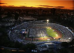
Guatemala City possesses several sportsgrounds and is home to many sports clubs. Football is the most popular sport, with CSD Municipal, Aurora FC and Comunicaciones being the main clubs. The Estadio Mateo Flores, located in the Zone 5 of the city, is the largest stadium in the country, followed in capacity by the Estadio Cementos Progreso and the Estadio del Ejército. An important multi-functional hall is the Domo Polideportivo de la CDAG.
The city has hosted several international sports events: in 1950 it hosted the VI Central American and Caribbean Games, and in 2000 the FIFA Futsal World Championship. On July 4, 2007 the International Olympic Committee gathered in Guatemala City and voted Sochi to become the host for the 2014 Winter Olympics and Paralympics.[14] In April of 2010, it hosted the XIVth Pan-American Mountain Bike Championships.[15]
Guatemala City was announced in November 2007 to host the 2008 edition of the CONCACAF Futsal Championship, played at the Domo Polideportivo from June 2 to June 8, 2008.[16][17]
Crime
In 2008, approximately 40 murders a week were reported in Guatemala City alone. While the vast majority of murders do not involve foreigners, the sheer volume of activity and the limited resources makes local officials and police, who are inexperienced and underpaid, unable to cope with the problem. The judicial system is weak, overworked, and inefficient, hence further compounding the crime problem.[18] There have been proposals to create a criminal justice program in the country and require police officers to have such studies. Higher studies would also be coupled with higher pay. This has only remained in the discussion stage, without any advances, despite the increased criminal wave that has plagued the city and country in the past decade or so.
Natural disasters
Earthquakes
Guatemala City has been affected several times by earthquakes. The worst quakes were registered in 1917/1918 and 1976.
Volcanic activity
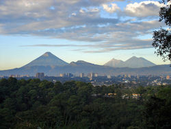
Four volcanoes are visible from the city, two of them active. The nearest and most active is Pacaya, which at times expels a considerable amount of ash.[19]
Mudslides
Due to heavy rainfalls some of the humble neighborhoods built at the edge of steep valleys are frequently washed away and buried under mudslides, as in October 2005.[20]
Piping Pseudokarst
In February 2007, a large, deep circular hole with vertical walls opened in a poor neighborhood in northeast Guatemala city , killing three people. This hole, which is classified by geologists as either a "piping feature" or "piping pseudokarst" and incorrectly referred to as a "sinkhole" by the popular press, was 100 m (330 ft) deep, and apparently was created by fluid from a sewer eroding uncemented volcanic (pyroclastic) deposits underlying Guatemala City.[21][22] As a result, one thousand people were evacuated from the area.[23] The piping feature has since been mitigated and plans to develop on the site have been proposed. However, critics believe municipal authorities have neglected needed maintenance on the city's aging sewer system, and have speculated that more piping features are likely to develop unless action is taken. [24]
In May 2010, another piping feature, which was larger than a street intersection and also incorrectly referred to as a "sinkhole" by the popular press, developed after Tropical Storm Agatha. It engulfed a three story building and a house. [25] This 2010 piping feature is at least 18 m (60 ft) wide and 60 m (200 ft) deep.[26][27] The distance between the 2010 piping feature and the 2007 piping feature three years ago is about two kilometers (according to their coordinates). Geologists Sam Bonis and T. Waltham argue that the recurring piping features in Guatemala are caused by sewer leaks eroding soft volcanic deposits underlying Guatemala City.[21][28]
Zone Ten and Zona Viva
Zone Ten, along with being the financial district of the city, is among the most popular areas for pop culture, shopping and entertainment. A district within Zone Ten, known as Zona Viva, contains many of the city's most popular and most expensive hotels, restaurants, bars, discothèques, and other entertainment venues for urban dwellers. Also, many of the embassies are located in Zone Ten.
International relations
Twin towns — sister cities
Guatemala City is twinned with:
|
City's notable offspring
- Pablo Jose Quan Lopez, National Karate Champion
- Raúl Aguilar Batres, Engineer, creator of Guatemala City's system of avenue/street notation
- Miguel Ángel Asturias, writer and diplomat, Nobel Prize Laureate
- Manuel Colom Argueta, Former mayor of Guatemala City and renowed politician
- Carlos Mérida, painter
- Carlos Peña, singer, Winner of Latin American Idol 2007
- Fernando Quevedo, Theoretical Physicist, currently a professor of High Energy Psysics at the university of Cambridge
- Rodolfo Robles, Physician, discovered onchocercosis "Robles' Disease"
- Fabiola Rodas, Winner of The Third TV Azteca's Desafio de Estrellas 2nd Place in The Last Generation of La Academia
- Carlos Ruíz, football/soccer player
- Shery, singer / songwriter
- Jaime Viñals, Mountaineer (Scaled seven highest peaks in the world)
- Luis von Ahn, Computer Scientist, CAPTCHA's creator and Researcher at Carnegie Mellon University
- Ted Hendricks, Oakland Raiders NFL Hall Of Fame Linebacker. 5-Time Super Bowl Champion
- Ricardo Arjona, Singer /songwriter
- Juan José Gutiérrez, CEO of Pollo Campero and on the board of directors of Corporación Multi Inversiones. Has been featured on the cover of Newsweek as Super CEO and named one of the Ten Big Thinkers for Big Business.[30]
See also
- 2007 Guatemala earthquake
- La Aurora International Airport
- Guatemala City travel guide from Wikitravel
References
Notes
- ↑ "Guatemala: largest cities and towns and statistics of their population". World Gazeteer. http://world-gazetteer.com/wg.php?x=&men=gcis&lng=en&des=wg&geo=-93&srt=pnan&col=abcdefghinoq&msz=1500. Retrieved 2010-02-24.
- ↑ 2.0 2.1 "Guatemala: metropolitan areas". World Gazeteer. http://world-gazetteer.com/wg.php?x=&men=gcis&lng=en&des=wg&geo=-93&srt=pnan&col=abcdefghinoq&msz=1500&va=&pt=a. Retrieved 2010-02-24.
- ↑ José Omar Moncada Maya. "En torno a la destrucción de la ciudad de Guatemala, 1773. Una carta del ingeniero militar Antonio Marín". Ub.es. http://www.ub.es/geocrit/b3w-444.htm. Retrieved 2009-07-08.
- ↑ 4.0 4.1 "World Weather Information Service - Guatemala City". http://worldweather.wmo.int/152/c00906.htm. Retrieved 2010-05-09.
- ↑ 5.0 5.1 Weatherbase: Historical Weather for Guatemala City, Guatemala
- ↑ http://pot.muniguate.com/reglamento_pot_mapa.php
- ↑ ":::... Plan de Ordenamiento Territorial - Tú eres la Ciudad, Municipalidad de Guatemala, cumple ...:::" (in ). Pot.muniguate.com. http://pot.muniguate.com/. Retrieved 2009-07-08.
- ↑ http://pot.muniguate.com/reglamento_pot_mapa.php
- ↑ "Mapa en Relieve de Guatemala". Web.archive.org. http://web.archive.org/web/20080209212714/http://www.funtec-guatemala.org/page6.html. Retrieved 2009-07-25.
- ↑ "Museo Ixchel". Web.archive.org. 2008-02-02. http://web.archive.org/web/20080202120854/http://www.museoixchel.org/. Retrieved 2009-07-25.
- ↑ "Jardin Botanico". Natureserve.org. http://www.natureserve.org/nhp/lacarb/guate/jardin_botanico.htm. Retrieved 2009-07-25.
- ↑ "Museo Nacional de Arqueologia y Etnologia de Guatemala - deGUATE.com". deGUATE.com<!. http://www.deguate.com/infocentros/entretenimiento/arteycultura/arteycultura/museo-arque.htm. Retrieved 2009-07-25.
- ↑ "Zoológico". Aurorazoo.org.gt. http://aurorazoo.org.gt/pages/intro.php. Retrieved 2009-07-25.
- ↑ rga-online, Remscheid, Germany. "Topnews - Sport - Remscheid: Remscheider General-Anzeiger / rga-online ...weil wir hier zu Hause sind!". Rga-online.de. http://www.rga-online.de/sport/topnews.php?publikation=2&template=phparttext_tt&ausgabe=42929&redaktion=1&artikel=108623013. Retrieved 2009-07-08.
- ↑ http://www.guatepanamericanomtb2010.com/ XIVth Pan-American Mountain Bike Championships
- ↑ "2008 CONCACAF Futsal Championship to take place in Guatemala". CONCACAF. http://www.concacaf.com/competitions/futsal/viewArticle.asp?lang=en&id=4024. Retrieved 2008-03-29.
- ↑ "2008 CONCACAF Futsal Championship Logo Unveiled". CONCACAF. http://www.concacaf.com/competitions/futsal/viewArticle.asp?lang=en&id=4097. Retrieved 2008-03-29.
- ↑ http://travel.state.gov/travel/cis_pa_tw/cis/cis_1129.html
- ↑ "MTU-VP Pacaya Volcano, Guatemala". Geo.mtu.edu. 1995-06-01. http://www.geo.mtu.edu/volcanoes/central_america/guatemala/pacaya/gvn/sepgvn.html. Retrieved 2009-07-08.
- ↑ Carlos, Juan (2005-10-07). "Mudslide in Guatemala kills dozens | The San Diego Union-Tribune". Signonsandiego.com. http://www.signonsandiego.com/uniontrib/20051007/news_1n7stan.html. Retrieved 2009-07-08.
- ↑ 21.0 21.1 Waltham, T., 2008, Sinkhole hazard case histories in karst terrains. Quarterly Journal of Engineering Geology and Hydrogeology. vol. 41 no. 3, pp.. 291-300.
- ↑ Halliday, W. R., 2007, Pseudokarst in the 21st century. Journal of Cave and Karst Studies. vol. 69, no. 1, p. 103–113.
- ↑ David L Miller (2009-07-04). "Massive Guatemala Sinkhole Kills 2 Teens". CBS News. http://www.cbsnews.com/stories/2007/02/23/world/main2508879.shtml. Retrieved 2009-07-08.
- ↑ Constantino Diaz-Duran (2010-06-01). "Sinkhole in Guatemala City Might Not Be the Last". The Daily Beast. http://www.thedailybeast.com/blogs-and-stories/2010-06-01/sinkhole-in-guatemala-city-might-not-be-the-last/. Retrieved 2010-06-03.
- ↑ http://www.guardian.co.uk/world/2010/jun/01/storm-agatha-hole-guatemala
- ↑ GuatemalaSinkhole.org. "Guatemala Sinkhole". http://www.guatemalasinkhole.org. Retrieved 2010-06-01.
- ↑ Hole that swallowed a three-story building, Sydney Morning Herald, June 2, 2010
- ↑ Michael Reilly (2010-06-02). "Don't Call the Guatemala Sinkhole a Sinkhole". Discovery News. http://news.discovery.com/earth/dont-call-the-guatemala-sinkhole-a-sinkhole.html. Retrieved 2010-06-09.
- ↑ Madrid city council webpage "Mapa Mundi de las ciudades hermanadas". Ayuntamiento de Madrid. http://www.munimadrid.es/portal/site/munimadrid/menuitem.dbd5147a4ba1b0aa7d245f019fc08a0c/?vgnextoid=4e84399a03003110VgnVCM2000000c205a0aRCRD&vgnextchannel=4e98823d3a37a010VgnVCM100000d90ca8c0RCRD&vgnextfmt=especial1&idContenido=1da69a4192b5b010VgnVCM100000d90ca8c0RCRD Madrid city council webpage. Retrieved 2009-07-25.
- ↑ http://www.newsweek.com/id/49842/page/4
External links
|
|||||||||||